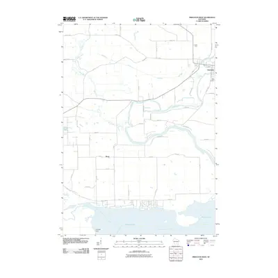
2010 Map of Princeton West
USGS Topo · Published 2010About this map
The Fox River meanders through the landscape near Princeton, where its waters were historically diverted through the Mill Race and Canal St areas. This 2010 survey shows the intricate water network where the Mecan River joins the Fox, flowing toward the expansive Puckaway Lake in the south. The settlement of Mecan and the Saint Johns Cemetery provide specific points of interest for genealogists and local historians tracking family roots in Green Lake County. The map details a transition from the structured grid of the city to the irregular shorelines of White Lake and Haystack Point, reflecting the region's long-standing reliance on its river systems for transport and industry. The presence of numerous county highways, including County Hwy-J and County Hwy-C, illustrates the modern road network overlying the historic water-based geography of the Fox River Valley.
Find a feature on this map
42 named features on this map. Tap any name to fly to it.
Don’t see what you’re looking for? This feature index may not catch every label — zoom into the map to look around manually.
Map Details
Editions of this 2010 Princeton West Map
This is the sole edition of this map. No revisions or reprints were ever made.
Other maps of this area

1902 · Portage
USGS Topo · 1:62,500

1915 · Neshkoro
USGS Topo · 1:48,000

1918 · Neshkoro
USGS Topo · 1:62,500

1955 · Randolph
USGS Topo · 1:62,500

1957 · Madison
USGS Topo · 1:250,000

1960 · Madison
USGS Topo · 1:250,000

1961 · Montello
USGS Topo · 1:62,500

1962 · Portage
USGS Topo · 1:62,500

1963 · Neshkoro
USGS Topo · 1:62,500
1980 · Manchester
USGS Topo · 1:24,000