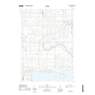
2018 Map of Princeton West
USGS Topo · Published 2018About this map
Puckaway Lake anchors the southern boundary of this central Wisconsin landscape, where the Fox River meanders eastward toward the settlement of Princeton. The map reveals a complex hydraulic network, including the Mecan River and a notable Mill Race that cuts across the terrain north of the main river channel. This area reflects a long history of river-based commerce and community planning, with the eastern edge of the survey capturing the core of Princeton, including its post office and central streets like W Main St and S Clinton St. Genealogists will find significant value in the documentation of local burial grounds, including the Princeton Cem, Saint Johns Catholic Cem, and Saint Johns Lutheran Cem. Further west, the small settlement of Mecan is situated near the riverbanks, while shoreline features such as Zacharias Island and Haystack Point define the northern reach of the lake.
Find a feature on this map
72 named features on this map. Tap any name to fly to it.
Don’t see what you’re looking for? This feature index may not catch every label — zoom into the map to look around manually.
Map Details
Editions of this 2018 Princeton West Map
This is the sole edition of this map. No revisions or reprints were ever made.
Other maps of this area

1902 · Portage
USGS Topo · 1:62,500

1915 · Neshkoro
USGS Topo · 1:48,000

1918 · Neshkoro
USGS Topo · 1:62,500

1955 · Randolph
USGS Topo · 1:62,500

1957 · Madison
USGS Topo · 1:250,000

1960 · Madison
USGS Topo · 1:250,000

1961 · Montello
USGS Topo · 1:62,500

1962 · Portage
USGS Topo · 1:62,500

1963 · Neshkoro
USGS Topo · 1:62,500
1980 · Manchester
USGS Topo · 1:24,000