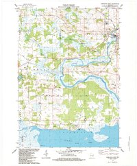
1984 Map of Princeton West
USGS Topo · Published 1984About this map
Puckaway Lake and the winding course of the Fox River dominate this 1984 survey of the borderlands between Marquette and Green Lake counties. The river exhibits complex hydrology through Oxbow Bend, while the adjacent Mill Race and numerous sandpits near Princeton indicate the area's historical reliance on both water power and geological extraction. Settlement patterns are concentrated in the northeast at Princeton and scattered throughout the township of Mecan, where local life is anchored by landmarks like Immanuel Ch and Townhall.
Find a feature on this map
40 named features on this map. Tap any name to fly to it.
Don’t see what you’re looking for? This feature index may not catch every label — zoom into the map to look around manually.
Map Details
Editions of this 1984 Princeton West Map
This is the sole edition of this map. No revisions or reprints were ever made.
Other maps of this area

1902 · Portage
USGS Topo · 1:62,500

1915 · Neshkoro
USGS Topo · 1:48,000

1918 · Neshkoro
USGS Topo · 1:62,500

1955 · Randolph
USGS Topo · 1:62,500

1957 · Madison
USGS Topo · 1:250,000

1960 · Madison
USGS Topo · 1:250,000

1961 · Montello
USGS Topo · 1:62,500

1962 · Portage
USGS Topo · 1:62,500

1963 · Neshkoro
USGS Topo · 1:62,500
1980 · Manchester
USGS Topo · 1:24,000