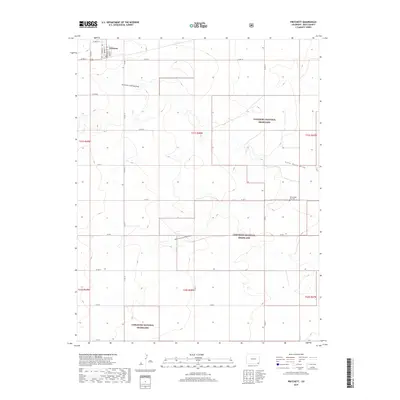
2019 Map of Pritchett
USGS Topo · Published 2019About this map
Pritchett sits in the northwest corner of this southeastern Colorado landscape, where the grid of the High Plains meets the intermittent drainage of the Comanche National Grassland. The town layout is defined by streets such as Howard St, Irving St, and Randolph St, serving as a localized hub for the surrounding ranching and agricultural country. The terrain is marked by the seasonal pathways of the North Fork Lone Rock Draw and the South Fork Lone Rock Draw, which cut subtle patterns across the shortgrass prairie.
Find a feature on this map
35 named features on this map. Tap any name to fly to it.
Don’t see what you’re looking for? This feature index may not catch every label — zoom into the map to look around manually.
Map Details
Editions of this 2019 Pritchett Map
This is the sole edition of this map. No revisions or reprints were ever made.
Other maps of this area

1891 · Springfield
USGS Topo · 1:125,000

1893 · Springfield
USGS Topo · 1:125,000

1955 · La Junta
USGS Topo · 1:250,000

1958 · La Junta
USGS Topo · 1:250,000

1968 · La Junta
USGS Topo · 1:250,000

1978 · Edler
USGS Topo · 1:24,000

1978 · Pritchett
USGS Topo · 1:24,000

1978 · Springfield SW
USGS Topo · 1:24,000
1978 · Harbord
USGS Topo · 1:24,000
1978 · Lone Rock
USGS Topo · 1:24,000