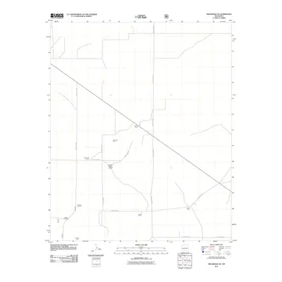
2011 Map of Progresso NE
USGS Topo · Published 2011About this map
The high plains of Torrance County are defined here by a network of isolated homesteads and essential water infrastructure during the early 21st century. Scattered throughout the landscape are legacy holdings such as Gustins Ranch, McGoragill Ranch, and Pound Ranch, illustrating the endurance of large-scale ranching in this arid environment. The survival of these operations is marked by specific landmarks like Devaney Windmill and Beedle Windmill, which signify the critical importance of groundwater access in a region otherwise dominated by dry features like Pueblo Blanco Canyon. A grid of county thoroughfares, including County Rd-B033 and County Rd-B084, connects these remote outposts across the high desert terrain.
Find a feature on this map
17 named features on this map. Tap any name to fly to it.
Don’t see what you’re looking for? This feature index may not catch every label — zoom into the map to look around manually.
Map Details
Editions of this 2011 Progresso NE Map
This is the sole edition of this map. No revisions or reprints were ever made.
Other maps of this area

1954 · Fort Sumner
USGS Topo · 1:250,000

1958 · Fort Sumner
USGS Topo · 1:250,000

1978 · Negra SW
USGS Topo · 1:24,000

1978 · Laguna Del Perro South
USGS Topo · 1:24,000

1978 · Rattlesnake Hill
USGS Topo · 1:24,000

1980 · Corona
USGS Topo · 1:100,000

1981 · Progresso NE
USGS Topo · 1:24,000

1981 · Pino Mountain
USGS Topo · 1:24,000
1981 · Progresso SW
USGS Topo · 1:24,000
1981 · Progresso
USGS Topo · 1:24,000