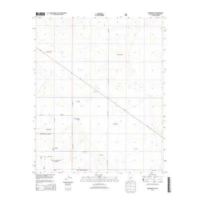
2013 Map of Progresso NE
USGS Topo · Published 2013About this map
The Cibola National Forest defines the southwestern terrain of this quadrangle, where high-desert ranching and water management shape the landscape. Remote outposts and family-named landmarks are scattered across the plains and canyon country, including Gustins Ranch, Hobbs Ranch, and the Pound Ranch. These sites, along with isolated infrastructure like the Devaney Windmill and Beedle Windmill, illustrate the critical reliance on groundwater in this arid region of Torrance County. The topography is further marked by the Pueblo Blanco Canyon, which provides a natural break in the land south of NM-42. This road network, including several county routes like CO Road B083 and CO Road B082, serves as the primary connection between these disparate rural holdings, showing a land use pattern focused on large-scale grazing and resource protection within the national forest boundaries.
Find a feature on this map
23 named features on this map. Tap any name to fly to it.
Don’t see what you’re looking for? This feature index may not catch every label — zoom into the map to look around manually.
Map Details
Editions of this 2013 Progresso NE Map
This is the sole edition of this map. No revisions or reprints were ever made.
Other maps of this area

1954 · Fort Sumner
USGS Topo · 1:250,000

1958 · Fort Sumner
USGS Topo · 1:250,000

1978 · Negra SW
USGS Topo · 1:24,000

1978 · Laguna Del Perro South
USGS Topo · 1:24,000

1978 · Rattlesnake Hill
USGS Topo · 1:24,000

1980 · Corona
USGS Topo · 1:100,000

1981 · Progresso NE
USGS Topo · 1:24,000

1981 · Pino Mountain
USGS Topo · 1:24,000
1981 · Progresso SW
USGS Topo · 1:24,000
1981 · Progresso
USGS Topo · 1:24,000