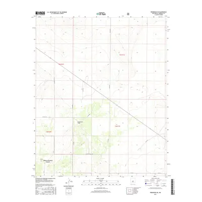
2017 Map of Progresso NE
USGS Topo · Published 2017About this map
Cibola National Forest encompasses the southwestern portion of this landscape in Torrance County, characterized by the dramatic incision of Pueblo Blanco Canyon. This 2017 survey reveals a network of local ranch and county roads that define the rural transit patterns of the high New Mexico plains. Principal arteries such as Progresso Rd, also designated as Co Rd 80/Progresso Rd, cross the territory alongside Humphree Ranch Rd, reflecting the enduring agricultural and ranching legacy of the region. The map provides a precise look at the township and range system, with boundaries like t3n r10e and t2n r11e clearly marked. Genealogists and historians can trace family landholdings through named local roads like Pardo Rd and the access points to the national forest lands.
Find a feature on this map
17 named features on this map. Tap any name to fly to it.
Don’t see what you’re looking for? This feature index may not catch every label — zoom into the map to look around manually.
Map Details
Editions of this 2017 Progresso NE Map
This is the sole edition of this map. No revisions or reprints were ever made.
Other maps of this area

1954 · Fort Sumner
USGS Topo · 1:250,000

1958 · Fort Sumner
USGS Topo · 1:250,000

1978 · Negra SW
USGS Topo · 1:24,000

1978 · Laguna Del Perro South
USGS Topo · 1:24,000

1978 · Rattlesnake Hill
USGS Topo · 1:24,000

1980 · Corona
USGS Topo · 1:100,000

1981 · Progresso NE
USGS Topo · 1:24,000

1981 · Pino Mountain
USGS Topo · 1:24,000
1981 · Progresso SW
USGS Topo · 1:24,000
1981 · Progresso
USGS Topo · 1:24,000