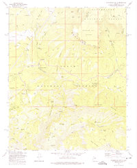
1973 Map of Promontory Butte
USGS Topo · Published 1975About this map
Mogollon Rim dominates this 1970s landscape, serving as a massive geological boundary that separates the Sitgreaves National Forest to the north from the Tonto National Forest to the south. The settlement pattern follows the canyon bottoms and reliable water sources, most notably at Kohls Ranch along Tonto Creek, where human habitation congregates at the base of the rim. Historical routes like the High Line Trail and Derrick Trail traverse the steep escarpments, illustrating the difficult transit between the high plateau and the basin below.
Find a feature on this map
72 named features on this map. Tap any name to fly to it.
Don’t see what you’re looking for? This feature index may not catch every label — zoom into the map to look around manually.
Map Details
Editions of this 1973 Promontory Butte Map
4 editions found
Other maps of this area

1886 · Holbrook
USGS Topo · 1:250,000

1887 · Verde
USGS Topo · 1:250,000

1892 · Verde
USGS Topo · 1:250,000

1893 · Holbrook
USGS Topo · 1:250,000

1934 · Promontory Butte
USGS Topo · 1:62,500

1937 · Diamond Butte
USGS Topo · 1:48,000

1939 · Promontory Butte
USGS Topo · 1:62,500

1943 · Diamond Butte
USGS Topo · 1:62,500

1952 · Promontory Butte
USGS Topo · 1:62,500

1954 · Holbrook
USGS Topo · 1:250,000
Featured Places
- Thompson Draw Summer Homes Unit #1, AZ
- Tonto Estate, AZ
- Hunter Creek, AZ
- Bear Flat, AZ
- Christopher Creek, AZ