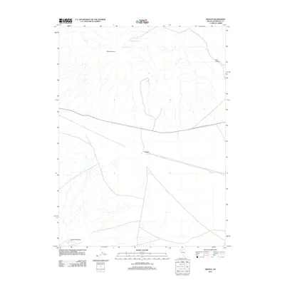
2011 Map of Pronto
USGS Topo · Published 2011About this map
Pronto serves as a lone namesake waypoint in this high desert landscape of Humboldt County, positioned along the southern edge of a rail corridor that traverses the Great Basin. The terrain is defined by dramatic elevation changes, rising from the valley floor toward the Blue Mountain massif in the north and the northern reaches of the Eugene Mountains at the southern boundary. These peaks and ridges are scarred by drainage networks, including Abel Canyon in the east, which channel seasonal runoff through the arid environment. Water sources are exceptionally rare and historically vital in this region, marked here by isolated points such as O'Donnell Spring and Sampson Spring. The sparse infrastructure seen in 2011 reflects the enduring isolation of this part of Nevada, where road networks remain minimal and land use is dictated by the availability of water and the orientation of the surrounding mountain ranges.
Find a feature on this map
6 named features on this map. Tap any name to fly to it.
Don’t see what you’re looking for? This feature index may not catch every label — zoom into the map to look around manually.
Map Details
Editions of this 2011 Pronto Map
This is the sole edition of this map. No revisions or reprints were ever made.
Other maps of this area

1882 · Paradise
USGS Topo · 1:250,000

1886 · Disaster
USGS Topo · 1:250,000

1893 · Paradise
USGS Topo · 1:250,000

1893 · Disaster
USGS Topo · 1:250,000

1931 · Lovelock
USGS Topo · 1:250,000

1932 · Sonoma Range
USGS Topo · 1:250,000

1935 · Lovelock
USGS Topo · 1:250,000

1939 · Sonoma Range
USGS Topo · 1:250,000

1939 · Eugene Mountains Area
USGS Topo · 1:62,500

1942 · Eugene Mountains Area
USGS Topo · 1:62,500