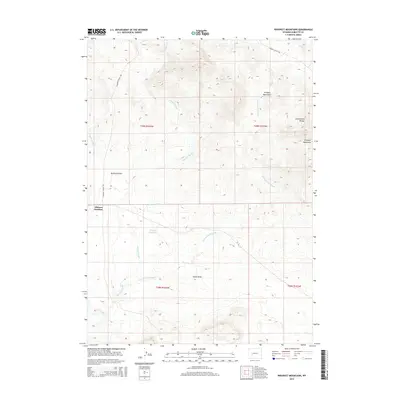
2015 Map of Prospect Mountains
USGS Topo · Published 2015About this map
Prospect Mountains dominate this high-altitude landscape in Sublette County, where the Continental Divide traces a rugged path through the terrain. The map highlights a critical junction of historic western travel routes, specifically where the Lander Cutoff Rd and Elkhorn Cutoff Rd converge near Elkhorn Junction. This area serves as a significant drainage basin, characterized by a complex network of seasonal waterways including Mitchell Slough, Little Mitchell Slough, and Alkali Draw.
Find a feature on this map
16 named features on this map. Tap any name to fly to it.
Don’t see what you’re looking for? This feature index may not catch every label — zoom into the map to look around manually.
Map Details
Editions of this 2015 Prospect Mountains Map
This is the sole edition of this map. No revisions or reprints were ever made.
Other maps of this area

1955 · Lander
USGS Topo · 1:250,000

1958 · Lander
USGS Topo · 1:250,000

1958 · Parting of the Ways
USGS Topo · 1:62,500

1958 · Hay Meadow Reservoir
USGS Topo · 1:24,000

1958 · Parting of the Ways
USGS Topo · 1:24,000

1961 · Lander
USGS Topo · 1:250,000

1969 · Leckie Reservoir
USGS Topo · 1:24,000

1969 · Jensen Meadows
USGS Topo · 1:24,000
1969 · Big Sandy Reservoir SE
USGS Topo · 1:24,000
1969 · Sweetwater Needles
USGS Topo · 1:24,000