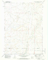
1969 Map of Big Sandy Reservoir SE
USGS Topo · Published 1973About this map
The Emigrant Trail bisects the high plains of this Wyoming landscape, following the southern reaches of the Little Sandy Creek. This survey captures a remote section of the historic westward migration route, specifically featuring the (Sublette Cutoff) which separates from the main trail near the Sublette and Sweetwater County line. The terrain is marked by essential water management features for this arid region, including Chambers Ditch and reservoirs like Little Sandy Res No 2 and Little Sandy Res No 3. Industrial activity is sparse, noted primarily by the presence of Spicer Well No 2, indicating mineral exploration or water extraction during the late 1960s. The map illustrates a landscape where modern infrastructure and historic trail paths overlap near the edge of the Big Sandy drainage.
Find a feature on this map
8 named features on this map. Tap any name to fly to it.
Don’t see what you’re looking for? This feature index may not catch every label — zoom into the map to look around manually.
Map Details
Editions of this 1969 Big Sandy Reservoir SE Map
2 editions found
Other maps of this area

1955 · Lander
USGS Topo · 1:250,000

1958 · Lander
USGS Topo · 1:250,000

1958 · Parting of the Ways
USGS Topo · 1:62,500

1958 · Essex Mountain
USGS Topo · 1:62,500

1958 · Tule Butte
USGS Topo · 1:24,000

1958 · Parting of the Ways
USGS Topo · 1:24,000

1961 · Lander
USGS Topo · 1:250,000

1968 · Eden Reservoir East
USGS Topo · 1:24,000
1968 · Eden Reservoir West
USGS Topo · 1:24,000

1969 · Leckie Reservoir
USGS Topo · 1:24,000