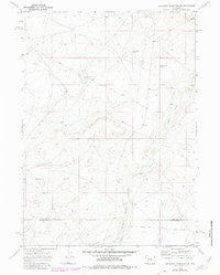
1969 Map of Big Sandy Reservoir SE
USGS Topo · Published 1980About this map
The Emigrant Trail traverses the high plains along the border of Sublette and Sweetwater counties, preserving the historical path of westward migration through Wyoming. This high-altitude desert landscape is defined by the winding course of Little Sandy Creek, which feeds into reservoirs such as Little Sandy Res No 2 and Little Sandy Res No 3. These water management features, along with the Chambers Ditch, illustrate the vital role of irrigation and water control in sustaining ranching and habitation in this arid environment.
Find a feature on this map
8 named features on this map. Tap any name to fly to it.
Don’t see what you’re looking for? This feature index may not catch every label — zoom into the map to look around manually.
Map Details
Editions of this 1969 Big Sandy Reservoir SE Map
2 editions found
Other maps of this area

1955 · Lander
USGS Topo · 1:250,000

1958 · Lander
USGS Topo · 1:250,000

1958 · Parting of the Ways
USGS Topo · 1:62,500

1958 · Essex Mountain
USGS Topo · 1:62,500

1958 · Tule Butte
USGS Topo · 1:24,000

1958 · Parting of the Ways
USGS Topo · 1:24,000

1961 · Lander
USGS Topo · 1:250,000

1968 · Eden Reservoir East
USGS Topo · 1:24,000
1968 · Eden Reservoir West
USGS Topo · 1:24,000

1969 · Leckie Reservoir
USGS Topo · 1:24,000