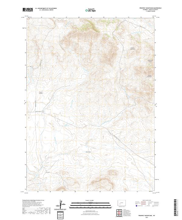
2021 Map of Prospect Mountains
USGS Topo · Published 2021About this map
The Continental Divide winds through this high-altitude landscape of Sublette County, marking the hydrological crest of the region. The map preserves the pathways of westward expansion, most notably the Lander Cutoff Rd, which provided emigrants on the Oregon Trail a shorter route through the mountains. These historic thoroughfares, including the Lander Pinedale Stage Rd, follow the natural contours of the Prospect Mountains and traverse open basins like Rollins Bottom.
Find a feature on this map
17 named features on this map. Tap any name to fly to it.
Don’t see what you’re looking for? This feature index may not catch every label — zoom into the map to look around manually.
Map Details
Editions of this 2021 Prospect Mountains Map
This is the sole edition of this map. No revisions or reprints were ever made.
Other maps of this area

1955 · Lander
USGS Topo · 1:250,000

1958 · Lander
USGS Topo · 1:250,000

1958 · Parting of the Ways
USGS Topo · 1:62,500

1958 · Hay Meadow Reservoir
USGS Topo · 1:24,000

1958 · Parting of the Ways
USGS Topo · 1:24,000

1961 · Lander
USGS Topo · 1:250,000

1969 · Leckie Reservoir
USGS Topo · 1:24,000

1969 · Jensen Meadows
USGS Topo · 1:24,000
1969 · Big Sandy Reservoir SE
USGS Topo · 1:24,000
1969 · Sweetwater Needles
USGS Topo · 1:24,000