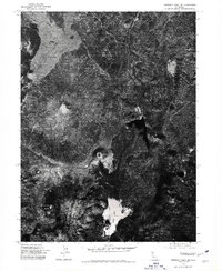
1975 Map of Prospect Peak SE
USGS Topo · Published 1981About this map
The stark volcanic landscape of the southern Cascades is captured in high detail on this 1975 orthophotoquad. Centered on the unmistakable symmetry of Cinder Cone, the imagery reveals the massive lava flows that once dammed the valley to create Snag Lake. This visual record from the mid-1970s provides a clear view of the geologic transition between the high summits of Prospect Peak and Fairfield Peak and the low-lying waters below. The overhead perspective allows for a precise study of forest cover and volcanic debris patterns before decades of subsequent ecological shifts, making it a valuable resource for tracing the natural history of this specific California wilderness.
Find a feature on this map
4 named features on this map. Tap any name to fly to it.
Don’t see what you’re looking for? This feature index may not catch every label — zoom into the map to look around manually.
Map Details
Editions of this 1975 Prospect Peak SE Map
This is the sole edition of this map. No revisions or reprints were ever made.
Other maps of this area

1886 · Lassen Peak
USGS Topo · 1:250,000

1892 · Lassen Peak
USGS Topo · 1:250,000

1894 · Lassen Peak
USGS Topo · 1:250,000

1939 · Halls Flat
USGS Topo · 1:125,000

1955 · Westwood
USGS Topo · 1:250,000

1956 · Mt. Harkness
USGS Topo · 1:62,500

1956 · Chester
USGS Topo · 1:62,500

1956 · Harvey Mtn
USGS Topo · 1:62,500

1957 · Prospect Peak
USGS Topo · 1:62,500

1958 · Westwood
USGS Topo · 1:250,000