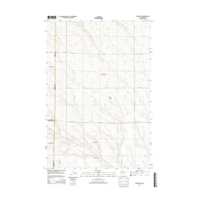
2013 Map of Prosser SE
USGS Topo · Published 2013About this map
Youngs Ranch and the surrounding high desert terrain characterize this portion of the Yakima Valley hinterlands. The landscape is defined by the convergence of several county lines, where Yakima, Benton, and Klickitat counties meet amidst a network of drainage ways and canyons. Water sources are critical markers in this arid environment, evidenced by McKinley Springs and the seasonal flow of Glade Cr.
Find a feature on this map
20 named features on this map. Tap any name to fly to it.
Don’t see what you’re looking for? This feature index may not catch every label — zoom into the map to look around manually.
Map Details
Editions of this 2013 Prosser SE Map
This is the sole edition of this map. No revisions or reprints were ever made.
Other maps of this area

1906 · Blalock Island
USGS Topo · 1:125,000

1908 · Blalock Island
USGS Topo · 1:125,000

1915 · Prosser
USGS Topo · 1:125,000

1917 · Prosser
USGS Topo · 1:125,000

1953 · Pendleton
USGS Topo · 1:250,000

1953 · Walla Walla
USGS Topo · 1:250,000

1955 · Prosser SW
USGS Topo · 1:24,000

1956 · Pendleton
USGS Topo · 1:250,000

1958 · Walla Walla
USGS Topo · 1:250,000
1962 · Phinny Hill
USGS Topo · 1:24,000