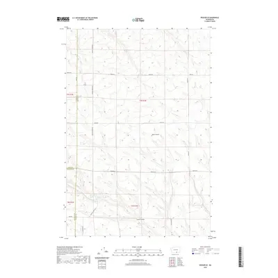
2020 Map of Prosser SE
USGS Topo · Published 2020About this map
Glade Cr winds through this arid section of the Horse Heaven Hills, carving deep drainages like Moore Canyon and Coyote Canyon. The landscape is defined by a strictly etched grid of rural tracks, including McKinley Springs Rd and Horrigan Rd, which navigate the high-elevation ridges between Yakima, Benton, and Klickitat counties. This 2020 survey by the U.S. Geological Survey reveals a modern agricultural and ranching environment where section lines dictate movement. These roads, such as Farnum Rd and Poeckes Rd, trace the high plateaus above the Columbia River basin, providing essential access to this high-desert terrain. The convergence of three county boundaries near Smith Rd highlights the administrative importance of this sparsely populated but topographically complex region.
Find a feature on this map
20 named features on this map. Tap any name to fly to it.
Don’t see what you’re looking for? This feature index may not catch every label — zoom into the map to look around manually.
Map Details
Editions of this 2020 Prosser SE Map
This is the sole edition of this map. No revisions or reprints were ever made.
Other maps of this area

1906 · Blalock Island
USGS Topo · 1:125,000

1908 · Blalock Island
USGS Topo · 1:125,000

1915 · Prosser
USGS Topo · 1:125,000

1917 · Prosser
USGS Topo · 1:125,000

1953 · Pendleton
USGS Topo · 1:250,000

1953 · Walla Walla
USGS Topo · 1:250,000

1955 · Prosser SW
USGS Topo · 1:24,000

1956 · Pendleton
USGS Topo · 1:250,000

1958 · Walla Walla
USGS Topo · 1:250,000
1962 · Phinny Hill
USGS Topo · 1:24,000