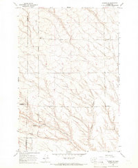
1965 Map of Prosser SE
USGS Topo · Published 1966About this map
The high plateau and canyon country of the Yakima and Benton County line comes into sharp focus through this mid-1960s topographic study. The landscape is defined by the sharp descent of Coyote Canyon and Moore Canyon as they drain toward the south, cutting through the dry upland terrain. Settlement patterns are sparse and agriculturally focused, centered around remote outposts like Youngs Ranch and a network of named section roads that reveal the early ranching history of the region.
Find a feature on this map
18 named features on this map. Tap any name to fly to it.
Don’t see what you’re looking for? This feature index may not catch every label — zoom into the map to look around manually.
Map Details
Editions of this 1965 Prosser SE Map
This is the sole edition of this map. No revisions or reprints were ever made.
Other maps of this area

1906 · Blalock Island
USGS Topo · 1:125,000

1908 · Blalock Island
USGS Topo · 1:125,000

1915 · Prosser
USGS Topo · 1:125,000

1917 · Prosser
USGS Topo · 1:125,000

1953 · Pendleton
USGS Topo · 1:250,000

1953 · Walla Walla
USGS Topo · 1:250,000

1955 · Prosser SW
USGS Topo · 1:24,000

1956 · Pendleton
USGS Topo · 1:250,000

1958 · Walla Walla
USGS Topo · 1:250,000
1962 · Phinny Hill
USGS Topo · 1:24,000