
1943 Map of Protem
USGS Topo · Published 1943About this map
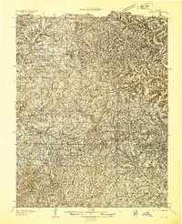
The Mark Twain National Forest dominates this section of the Ozarks during the early 1940s, featuring a landscape defined by sharp ridges and deep hollows. This era shows the Mark Twain Game Refuge at its heart, while the White River carves a dramatic path through Horseshoe Bend in the southwest corner. The settlement pattern is largely rural and school-centric, with dozens of local schoolhouses like Union Flat Sch, Ironsides Sch, and Hester Sch serving isolated ridge-top and valley communities.
Find a feature on this map
72 named features on this map. Tap any name to fly to it.
Don’t see what you’re looking for? This feature index may not catch every label — zoom into the map to look around manually.
Map Details
Editions of this 1943 Protem Map
This is the sole edition of this map. No revisions or reprints were ever made.
Other maps of this area

1893 · Yellville
USGS Topo · 1:125,000

1903 · Yellville
USGS Topo · 1:125,000

1904 · Harrison
USGS Topo · 1:125,000

1905 · Harrison
USGS Topo · 1:125,000

1905 · Yellville
USGS Topo · 1:125,000

1907 · Forsyth
USGS Topo · 1:125,000

1929 · Yellville
USGS Topo · 1:125,000

1936 · Thornfield
USGS Topo · 1:48,000
1936 · Ava
USGS Topo · 1:48,000

1937 · Bradleyville
USGS Topo · 1:48,000