
1937 Map of Bradleyville
USGS Topo · Published 1937About this map
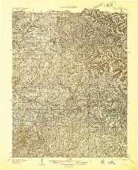
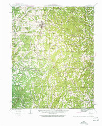
Big Beaver Creek and its many tributaries, such as Merritt Br and Browns Branch, define the deep drainage patterns across this portion of Douglas County. The landscape in the late 1930s is remarkably dense with rural institutions, showing a network of neighborhood schoolhouses like Lone Star Sch, Kentucky Hollow Sch, and Union Grove Sch that served isolated upland communities. The map captures an era of shifting centers, specifically noting older sites like Old Merritt and Old Ray alongside their newer counterparts.
Find a feature on this map
42 named features on this map. Tap any name to fly to it.
Don’t see what you’re looking for? This feature index may not catch every label — zoom into the map to look around manually.
Map Details
Editions of this 1937 Bradleyville Map
This is the sole edition of this map. No revisions or reprints were ever made.
Other maps of this area

1884 · Springfield
USGS Topo · 1:125,000

1886 · Springfield
USGS Topo · 1:125,000

1907 · Forsyth
USGS Topo · 1:125,000

1936 · Thornfield
USGS Topo · 1:48,000
1936 · Ava
USGS Topo · 1:48,000
1937 · Ozark
USGS Topo · 1:48,000
1939 · Fordland
USGS Topo · 1:62,500
1942 · Fordland
USGS Topo · 1:62,500
1942 · Ava
USGS Topo · 1:62,500

1943 · Protem
USGS Topo · 1:62,500