
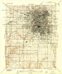
1884 Map of Springfield
USGS Topo · Published 1884About this map
Springfield sits at the nexus of a burgeoning transportation network in the mid-1880s, where the St. Louis and San Francisco Railroad and the Kansas City and Scott, Gulf Railroad converge. This survey by Topographer R.U. Goode reveals a landscape organized by both topography and administrative township boundaries, including Campbell, Robberson, and Washington. Small settlements and rural post offices like Fair Grove, Cave Spring, and Ebenezer dot the countryside, connected by early road systems that follow the high ground between local drainages.
Find a feature on this map
68 named features on this map. Tap any name to fly to it.
Don’t see what you’re looking for? This feature index may not catch every label — zoom into the map to look around manually.
Map Details
Editions of this 1884 Springfield Map
This is the sole edition of this map. No revisions or reprints were ever made.
Other maps of this area

1884 · Bolivar
USGS Topo · 1:125,000

1886 · Stockton
USGS Topo · 1:125,000

1886 · Greenfield
USGS Topo · 1:125,000

1886 · Springfield
USGS Topo · 1:125,000

1888 · Greenfield
USGS Topo · 1:125,000

1892 · Bolivar
USGS Topo · 1:125,000

1907 · Forsyth
USGS Topo · 1:125,000

1919 · Halltown
USGS Topo · 1:62,500
1935 · Springfield
USGS Topo · 1:24,000
1936 · Brookline
USGS Topo · 1:24,000