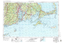
1947 Map of Providence
USGS Topo · Published 1988About this map
The industrial and maritime hubs of Providence, Fall River, and New Bedford anchor this 1947 regional view, which captures the Southern New England coast during a period of significant military and infrastructure transition. The rail networks of the New York New Haven and Hartford and the Boston and Albany lines are shown in high detail, illustrating the connective tissue between major textile cities and the Atlantic ports.
Find a feature on this map
73 named features on this map. Tap any name to fly to it.
Don’t see what you’re looking for? This feature index may not catch every label — zoom into the map to look around manually.
Map Details
Editions of this 1947 Providence Map
5 editions found

Other maps of this area

1885 · New Bedford
USGS Topo · 1:62,500

1885 · Abington
USGS Topo · 1:62,500

1885 · Sakonnet
USGS Topo · 1:62,500

1885 · Duxbury
USGS Topo · 1:62,500

1885 · Middleboro
USGS Topo · 1:62,500

1885 · Taunton
USGS Topo · 1:62,500

1886 · Falmouth
USGS Topo · 1:62,500

1886 · Blackstone
USGS Topo · 1:62,500

1886 · Plymouth
USGS Topo · 1:62,500

1886 · Dedham
USGS Topo · 1:62,500