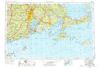
1947 Map of Providence
USGS Topo · Published 1976About this map
Providence serves as the focal point of this coastal survey, where the Blackstone River meets the head of Narragansett Bay. The landscape is dominated by a dense network of post-war infrastructure, showing the New York New Haven and Hartford RR connecting industrial centers like Pawtucket, Fall River, and New Bedford. This period marks a significant military footprint in the region, with the Quonset Point Naval Air Station and Newport Naval Base occupying strategic positions along the shoreline.
Find a feature on this map
143 named features on this map. Tap any name to fly to it.
Don’t see what you’re looking for? This feature index may not catch every label — zoom into the map to look around manually.
Map Details
Editions of this 1947 Providence Map
5 editions found

Other maps of this area

1885 · New Bedford
USGS Topo · 1:62,500

1885 · Abington
USGS Topo · 1:62,500

1885 · Sakonnet
USGS Topo · 1:62,500

1885 · Duxbury
USGS Topo · 1:62,500

1885 · Middleboro
USGS Topo · 1:62,500

1885 · Taunton
USGS Topo · 1:62,500

1886 · Falmouth
USGS Topo · 1:62,500

1886 · Blackstone
USGS Topo · 1:62,500

1886 · Plymouth
USGS Topo · 1:62,500

1886 · Dedham
USGS Topo · 1:62,500