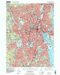
1996 Map of Providence
USGS Topo · Published 2000About this map
Brown University and Pembroke College anchor the academic core of this Rhode Island urban landscape, which shows the dense residential and industrial patterns of the late twentieth century. The map highlights a significant concentration of religious and social institutions, from the Franciscan Missionaries of Mary to numerous parochial schools like LaSalle Academy. The city's industrial legacy is visible along the winding Woonasquatucket River, where mill ponds such as Greystone Mill Pond and Allendale Mill Pond indicate former sites of production. Extensive green spaces and memorial sites, including the expansive Swan Point Cemetery and Roger Williams Park, provide a structured contrast to the tight-knit street grids of neighborhoods like Olneyville and Knightsville. The convergence of the Moshassuck River and Woonasquatucket River at the Providence River defines the downtown harbor area, characterized by maritime infrastructure at Sassafras Pt and Fields Point.
Find a feature on this map
207 named features on this map. Tap any name to fly to it.
Don’t see what you’re looking for? This feature index may not catch every label — zoom into the map to look around manually.
Map Details
Editions of this 1996 Providence Map
This is the sole edition of this map. No revisions or reprints were ever made.
Other maps of this area

1887 · Providence
USGS Topo · 1:62,500

1889 · Providence
USGS Topo · 1:62,500

1889 · Burrillville
USGS Topo · 1:62,500

1890 · Narragansett Bay
USGS Topo · 1:62,500

1890 · Kent
USGS Topo · 1:62,500

1892 · Narragansett Bay
USGS Topo · 1:62,500

1894 · Burrillville
USGS Topo · 1:62,500

1894 · Kent
USGS Topo · 1:62,500

1894 · Providence
USGS Topo · 1:62,500

1915 · Burrillville
USGS Topo · 1:62,500