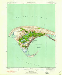
1949 Map of Provincetown
USGS Topo · Published 1958About this map
Provincetown sits at the curved tip of the Outer Cape, where the dense coastal settlement meets the shifting dunes of the Provincetown Lands State Reservation. This mid-century revision shows the community's maritime reliance alongside its growing aviation infrastructure at Provincetown Airport. The coastline is defined by critical navigation aids including Race Point Lighthouse and Long Point Lighthouse, which flank the deep waters of Provincetown Harbor.
Find a feature on this map
36 named features on this map. Tap any name to fly to it.
Don’t see what you’re looking for? This feature index may not catch every label — zoom into the map to look around manually.
Map Details
Editions of this 1949 Provincetown Map
2 editions found
Other maps of this area

1887 · Wellfleet
USGS Topo · 1:62,500

1887 · Provincetown
USGS Topo · 1:62,500

1889 · Provincetown
USGS Topo · 1:62,500

1889 · Wellfleet
USGS Topo · 1:62,500

1893 · Wellfleet
USGS Topo · 1:62,500

1898 · Provincetown
USGS Topo · 1:62,500

1942 · Cape Cod Bay
USGS Topo · 1:125,000

1944 · Provincetown
USGS Topo · 1:31,680
1944 · North Truro
USGS Topo · 1:31,680

1947 · Providence
USGS Topo · 1:250,000