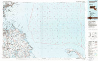
1984 Map of Provincetown
USGS Topo · Published 1986About this map
The coastal sweep of Massachusetts Bay and the tip of the Cape are captured in this mid-1980s planimetric study, which provides a detailed look at the maritime and defense infrastructure of the era. On the mainland, the dense suburban character of Hull and Hingham contrasts with the maritime installations like the U S Coast Guard Station and Northeastern Univ Edwards Laboratory at Nahant. This period shows the established footprint of Logan International Airport and the numerous islands of Boston Harbor, including Deer Island and Spectacle Island.
Find a feature on this map
176 named features on this map. Tap any name to fly to it.
Don’t see what you’re looking for? This feature index may not catch every label — zoom into the map to look around manually.
Map Details
Editions of this 1984 Provincetown Map
2 editions found
Other maps of this area

1885 · Abington
USGS Topo · 1:62,500

1885 · Duxbury
USGS Topo · 1:62,500

1885 · Middleboro
USGS Topo · 1:62,500

1885 · Taunton
USGS Topo · 1:62,500

1886 · Gloucester
USGS Topo · 1:62,500

1886 · Lawrence
USGS Topo · 1:62,500

1886 · Plymouth
USGS Topo · 1:62,500

1886 · Dedham
USGS Topo · 1:62,500

1887 · Wellfleet
USGS Topo · 1:62,500

1887 · Provincetown
USGS Topo · 1:62,500