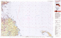
1984 Map of Provincetown
USGS Topo · Published 1994About this map
Cape Cod National Seashore and the tip of the peninsula dominate the southeastern quadrant of this study, which spans from the outer Cape across Massachusetts Bay to the South Shore and Boston's northern suburbs. The map reveals a mid-1980s landscape of maritime history and military presence, notably at the North Truro Air Force Station. A series of navigation markers including Wood End Lighthouse, Long Point Lighthouse, and Race Point Lighthouse define the hooked harbor at Provincetown.
Find a feature on this map
66 named features on this map. Tap any name to fly to it.
Don’t see what you’re looking for? This feature index may not catch every label — zoom into the map to look around manually.
Map Details
Editions of this 1984 Provincetown Map
2 editions found
Other maps of this area

1885 · Abington
USGS Topo · 1:62,500

1885 · Duxbury
USGS Topo · 1:62,500

1885 · Middleboro
USGS Topo · 1:62,500

1885 · Taunton
USGS Topo · 1:62,500

1886 · Gloucester
USGS Topo · 1:62,500

1886 · Lawrence
USGS Topo · 1:62,500

1886 · Plymouth
USGS Topo · 1:62,500

1886 · Dedham
USGS Topo · 1:62,500

1887 · Wellfleet
USGS Topo · 1:62,500

1887 · Provincetown
USGS Topo · 1:62,500