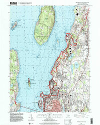
1996 Map of Prudence Island
USGS Topo · Published 2000About this map
Prudence Island and the surrounding waters of Narragansett Bay dominate this coastal landscape, which blends deep military history with rural island life. Large portions of the coastline are defined by the U S Naval Reservation and Gould Island WMA, reflecting the strategic maritime importance of the East Passage. Further inland, the map details the suburban and academic development of Middletown and South Portsmouth, where landmarks like the Priory Sch and Portsmouth Sch stand alongside significant local elevations such as Miantonomi Hill.
Find a feature on this map
73 named features on this map. Tap any name to fly to it.
Don’t see what you’re looking for? This feature index may not catch every label — zoom into the map to look around manually.
Map Details
Editions of this 1996 Prudence Island Map
This is the sole edition of this map. No revisions or reprints were ever made.
Other maps of this area

1885 · Sakonnet
USGS Topo · 1:62,500

1888 · Fall River
USGS Topo · 1:62,500

1888 · Sakonnet
USGS Topo · 1:62,500

1889 · Newport
USGS Topo · 1:62,500

1890 · Narragansett Bay
USGS Topo · 1:62,500

1892 · Narragansett Bay
USGS Topo · 1:62,500

1893 · Sakonnet
USGS Topo · 1:62,500

1893 · Fall River
USGS Topo · 1:62,500

1894 · Newport
USGS Topo · 1:62,500

1904 · Newport
USGS Topo · 1:62,500