2017 Map of Puertecito
USGS Topo · Published 2017About this map
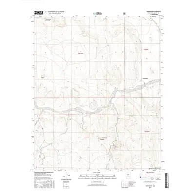
Rio Salado carves its way through the center of this high-desert landscape, defining the transition between the Cibola National Forest to the south and the mesa-topped terrain to the north. The small settlements of Alamo and Puertecito serve as the primary human centers, connected by a network of local routes like Co Rd 28 and Forest Rd 123. The topography is marked by distinct elevations such as White Peak and La Cruz Peak, which rise above the surrounding plateaus. To the north, Cottonwood Draw Mesa and Gag Mesa dominate the skyline, while drainage patterns are etched into the earth through Cottonwood Draw and Chavez Cr. Water sources, critical in this arid region, include the subterranean reach of Richard Spring and the seasonal flows through Abbe Spring Canyon and La Jara Canyon.
Find a feature on this map
23 named features on this map. Tap any name to fly to it.
Don’t see what you’re looking for? This feature index may not catch every label — zoom into the map to look around manually.
Map Details
Editions of this 2017 Puertecito Map
This is the sole edition of this map. No revisions or reprints were ever made.
Other maps of this area

1917 · Cerro Verde
USGS Topo · 1:125,000

1917 · Broom Mountain
USGS Topo · 1:125,000

1954 · Socorro
USGS Topo · 1:250,000

1958 · Socorro
USGS Topo · 1:250,000

1962 · Socorro
USGS Topo · 1:250,000

1964 · Indian Mesa
USGS Topo · 1:24,000

1964 · La Jara Peak
USGS Topo · 1:24,000

1964 · Table Mountain
USGS Topo · 1:24,000

1964 · Field Ranch
USGS Topo · 1:24,000

1964 · Puertecito
USGS Topo · 1:24,000
Featured Places
- Eastern Navajo Agency, NM
- John Padilla Settlement, Eastern Navajo Agency
- Puertecito, NM
- Alamo Springs, Eastern Navajo Agency
- Socorro County, NM