
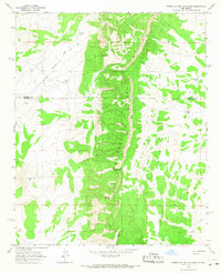
1964 Map of Puertecito
USGS Topo · Published 1967About this map
Puertecito sits at the northern edge of this high-desert landscape, where the Rio Salado winds through the drainage systems of Socorro County. To the south, the Cibola National Forest encompasses a complex terrain of canyons and peaks, including La Cruz Peak and the prominent White Peak. The map documents a sparsely populated ranching and indigenous landscape in the mid-1960s, evidenced by the Navajo Community Hall and localized sites like Chavez Ranch and the Bill Dobbs Well.
Find a feature on this map
21 named features on this map. Tap any name to fly to it.
Don’t see what you’re looking for? This feature index may not catch every label — zoom into the map to look around manually.
Map Details
Editions of this 1964 Puertecito Map
This is the sole edition of this map. No revisions or reprints were ever made.
Other maps of this area

1917 · Cerro Verde
USGS Topo · 1:125,000

1917 · Broom Mountain
USGS Topo · 1:125,000

1954 · Socorro
USGS Topo · 1:250,000

1958 · Socorro
USGS Topo · 1:250,000

1962 · Socorro
USGS Topo · 1:250,000

1964 · Indian Mesa
USGS Topo · 1:24,000

1964 · La Jara Peak
USGS Topo · 1:24,000

1964 · Table Mountain
USGS Topo · 1:24,000

1964 · Field Ranch
USGS Topo · 1:24,000
1964 · Puerto De Los Cavadores
USGS Topo · 1:24,000
Featured Places
- Eastern Navajo Agency, NM
- John Padilla Settlement, Eastern Navajo Agency
- Puertecito, NM
- Alamo Springs, Eastern Navajo Agency
- Socorro County, NM