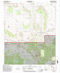
1995 Map of Puertecito
USGS Topo · Published 1998About this map
The Alamo Band Indian Reservation occupies a central role in this landscape of the mid-1990s, where traditional tribal territories meet the southern boundaries of the Cibola National Forest. The map documents a scattered settlement pattern characterized by family-named landmarks and rural outposts, including the John Padilla Settlement and Field Ranch. Cultural focal points are anchored by the Navajo Community Hall near the ephemeral watercourses that define the region's geography.
Find a feature on this map
24 named features on this map. Tap any name to fly to it.
Don’t see what you’re looking for? This feature index may not catch every label — zoom into the map to look around manually.
Map Details
Editions of this 1995 Puertecito Map
This is the sole edition of this map. No revisions or reprints were ever made.
Other maps of this area

1917 · Cerro Verde
USGS Topo · 1:125,000

1917 · Broom Mountain
USGS Topo · 1:125,000

1954 · Socorro
USGS Topo · 1:250,000

1958 · Socorro
USGS Topo · 1:250,000

1962 · Socorro
USGS Topo · 1:250,000

1964 · Indian Mesa
USGS Topo · 1:24,000

1964 · La Jara Peak
USGS Topo · 1:24,000

1964 · Table Mountain
USGS Topo · 1:24,000

1964 · Field Ranch
USGS Topo · 1:24,000

1964 · Puertecito
USGS Topo · 1:24,000
Featured Places
- Eastern Navajo Agency, NM
- John Padilla Settlement, Eastern Navajo Agency
- Puertecito, NM
- Alamo Springs, Eastern Navajo Agency
- Socorro County, NM