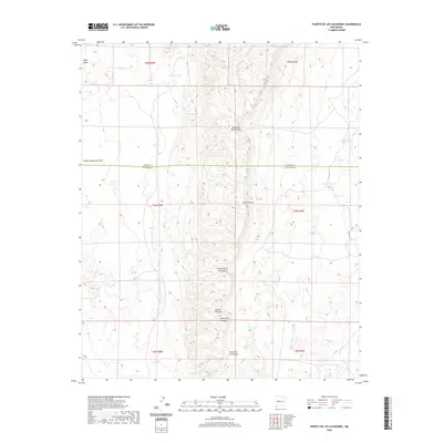
2020 Map of Puerto De Los Cavadores
USGS Topo · Published 2020About this map
Sierra Lucero dominates the central topography of this New Mexico landscape, serving as a prominent north-south ridge that defines the local drainage patterns. This high ground is punctuated by critical mountain passes, most notably Puerto de los Cavadores and Puerto de Bartolo Pino, which likely served as established transit points through the highland terrain. The intersection of Cibola and Socorro counties bisects the quadrangle, highlighting the administrative boundaries in this arid region. Ranching and livestock management are evidenced by the distribution of water catchments like Crowder Tank, Torres Tank, and Ten Tank, which are vital for supporting activity across the high desert. To the south, the Mesa de la Cienaga and the deepening Cañon de la Cienaga illustrate the transition from broad mesa tops to sharp canyon relief, while names like Chicken Mountain Draw and Hippy Draw provide a sense of the local naming traditions.
Find a feature on this map
19 named features on this map. Tap any name to fly to it.
Don’t see what you’re looking for? This feature index may not catch every label — zoom into the map to look around manually.
Map Details
Editions of this 2020 Puerto De Los Cavadores Map
This is the sole edition of this map. No revisions or reprints were ever made.
Other maps of this area

1917 · Cerro Verde
USGS Topo · 1:125,000

1954 · Socorro
USGS Topo · 1:250,000

1956 · Mesa Aparejo
USGS Topo · 1:62,500

1958 · Socorro
USGS Topo · 1:250,000

1959 · Riley
USGS Topo · 1:62,500

1962 · Socorro
USGS Topo · 1:250,000

1964 · La Jara Peak
USGS Topo · 1:24,000

1964 · Field Ranch
USGS Topo · 1:24,000
1964 · Cerro Del Oro
USGS Topo · 1:24,000
1964 · Chicken Mountain
USGS Topo · 1:24,000