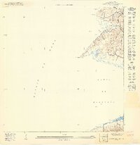
1949 Map of Puerto Real SO
USGS Topo · Published 1949About this map
Laguna Guaniquilla and the surrounding coastline of the Pedernales barrio define this 1949 survey of southwestern Puerto Rico. The landscape transitions from the heights of Cerro Guaniquilla down to the shores of the Bahia de Boqueron, revealing a coastal economy of small settlements and maritime industry. Near the northern boundary, the Estacion Cantera signifies active resource extraction, while the community at Col Cofresi is situated along the inland hills. The presence of Salinas in the south, positioned near the Peñones de Melones, points to the long-standing tradition of salt harvesting in this region. This preliminary map, prepared under Commissioner Jorge J. Jim nez of the Departamento de lo Interior, provides a localized look at the terrain before modern development altered the shoreline and the agricultural character of the barrios.
Find a feature on this map
15 named features on this map. Tap any name to fly to it.
Don’t see what you’re looking for? This feature index may not catch every label — zoom into the map to look around manually.
Map Details
Editions of this 1949 Puerto Real SO Map
This is the sole edition of this map. No revisions or reprints were ever made.
Other maps of this area

1935 · Puerto Real
USGS Topo · 1:25,000

1937 · Puerto Real
USGS Topo · 1:25,000

1938 · Cabo Rojo
USGS Topo · 1:30,000

1941 · Puerto Real
USGS Topo · 1:30,000
1949 · Puerto Real SE
USGS Topo · 1:10,000
1949 · Cabo Rojo NE
USGS Topo · 1:10,000
1949 · Puerto Real NE
USGS Topo · 1:10,000
1949 · Puerto Real NO
USGS Topo · 1:10,000
1949 · Cabo Rojo NO
USGS Topo · 1:10,000
1957 · Cabo Rojo
USGS Topo · 1:20,000