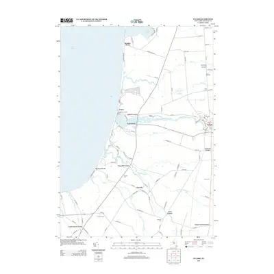
2013 Map of Pulaski
USGS Topo · Published 2013About this map
The Salmon River carves through the landscape of Richland, flowing from the village of Pulaski westward toward its outlet at Lake Ontario. In this early 21st-century study, the shoreline area is defined by a cluster of waterfront communities including Selkirk, Rainbow Shores, and Ramona Beach, supported by landmarks like the Selkirk Lighthouse and Lighthouse Marina. The interior of the county reflects a long-standing agricultural and rural pattern, evident in the numerous family-named junctions such as Bethel Corners, Daysville Corner, and Tinker Tavern Corner. The presence of several graveyards, including the Brown's Landing Cem and S Richland Cem, provides essential points of reference for genealogists. To the south, Hurlbut Orchards and the Trust Nursery highlight the continued importance of the region's nursery and fruit-growing industries, while the drainage of Grindstone Cr and Deer Cr dictates the local topography between the settled corners and the lakefront.
Find a feature on this map
98 named features on this map. Tap any name to fly to it.
Don’t see what you’re looking for? This feature index may not catch every label — zoom into the map to look around manually.
Map Details
Editions of this 2013 Pulaski Map
This is the sole edition of this map. No revisions or reprints were ever made.
Other maps of this area

1895 · Pulaski
USGS Topo · 1:62,500

1900 · Fulton
USGS Topo · 1:62,500

1905 · Mexico
USGS Topo · 1:62,500

1942 · Sandy Creek
USGS Topo · 1:24,000

1943 · Pulaski
USGS Topo · 1:31,680

1943 · New Haven
USGS Topo · 1:31,680

1943 · Richland
USGS Topo · 1:31,680

1943 · Texas
USGS Topo · 1:31,680

1943 · Mexico
USGS Topo · 1:31,680
1943 · Ellisburg
USGS Topo · 1:31,680