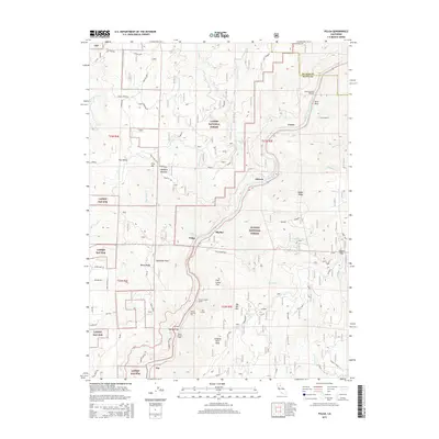
2015 Map of Pulga
USGS Topo · Published 2015About this map
The North Fork Feather River carves a deep path through this portion of the northern Sierra Nevada, serving as the primary corridor for both transportation and hydroelectric infrastructure. Tiny settlements and sidings like Pulga, Cresta, and Mayaro follow the river's bend, many tied to the heavy engineering required to traverse this landscape. A series of massive railroad and utility tunnels, including Cresta Tunnel, Poe Tunnel, and Tunnel Number Thirteen, reflect the historical effort to bridge the Feather River Canyon. High above the riverbed, the terrain rises toward peaks such as Hungary Hunt Peak and Big Bar Mtn, while the high country of Flea Valley and Campbell Meadow transitions into the protected lands of Lassen National Forest and Plumas National Forest. Local landmarks like Batchelor Point and Arch Rock provide orientation for those navigating the rugged county line between Butte and Plumas.
Find a feature on this map
73 named features on this map. Tap any name to fly to it.
Don’t see what you’re looking for? This feature index may not catch every label — zoom into the map to look around manually.
Map Details
Editions of this 2015 Pulga Map
This is the sole edition of this map. No revisions or reprints were ever made.
Other maps of this area

1888 · Bidwell Bar
USGS Topo · 1:125,000

1891 · Bidwell Bar
USGS Topo · 1:125,000

1891 · Chico
USGS Topo · 1:125,000

1893 · Chico
USGS Topo · 1:125,000

1893 · Bidwell Bar
USGS Topo · 1:125,000

1895 · Bidwell Bar
USGS Topo · 1:125,000

1895 · Chico
USGS Topo · 1:125,000

1897 · Bidwell Bar
USGS Topo · 1:125,000

1942 · Oroville
USGS Topo · 1:62,500
1944 · Oroville
USGS Topo · 1:62,500