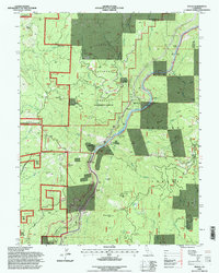
1994 Map of Pulga
USGS Topo · Published 1998About this map
The Feather River North Fork carves a deep path through the overlapping boundaries of the Lassen National Forest and the Plumas National Forest in this 1990s revision. The canyon floor is a corridor of infrastructure, where the Scenic Byway and a series of railroad tunnels, including Tunnel No 13 and Tunnel No 10, trace the river's edge. This era shows a landscape heavily managed for power and transport, evidenced by the Poe Dam, Cresta Powerhouse, and the Mill Creek Cal-Trans Station. Small settlements and isolated outposts like Pulga, Mayaro, and the Johnson Cabin remain tucked into the steep drainages of Concow Creek and Camp Creek. High points like Flea Mountain and Big Bar Mtn overlook the complex network of forest roads, including Rim Road and Bardee Road, that navigate the transition between Butte and Plumas counties.
Find a feature on this map
60 named features on this map. Tap any name to fly to it.
Don’t see what you’re looking for? This feature index may not catch every label — zoom into the map to look around manually.
Map Details
Editions of this 1994 Pulga Map
This is the sole edition of this map. No revisions or reprints were ever made.
Other maps of this area

1888 · Bidwell Bar
USGS Topo · 1:125,000

1891 · Bidwell Bar
USGS Topo · 1:125,000

1891 · Chico
USGS Topo · 1:125,000

1893 · Chico
USGS Topo · 1:125,000

1893 · Bidwell Bar
USGS Topo · 1:125,000

1895 · Bidwell Bar
USGS Topo · 1:125,000

1895 · Chico
USGS Topo · 1:125,000

1897 · Bidwell Bar
USGS Topo · 1:125,000

1942 · Oroville
USGS Topo · 1:62,500
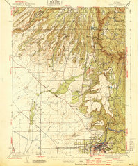
1944 · Oroville
USGS Topo · 1:62,500