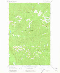
1963 Map of Pulpit Mountain
USGS Topo · Published 1981About this map
Kootenai National Forest dominates this landscape, showing a dense network of watercourses and high summits mapped during the early 1960s. The topography is defined by significant elevations like Pulpit Mountain and Skyline Mountain, with the drainage patterns of O'Brien Creek and its tributaries, such as Noseeum Creek and North Fork O'Brien Creek, carving through the terrain. A single small water body, Wee Lake, sits near the northern boundary under the shadow of Feeder Mountain. While the map lacks formal settlements, it documents the primitive infrastructure of the era, including a Jeep Trail and multiple sections of Pack Trail. These routes provided the primary access for forest management and recreation through the drainages of Hummingbird Creek and Rabbit Creek, reflecting a period when this portion of Lincoln County remained largely primitive and focused on natural resource navigation.
Find a feature on this map
20 named features on this map. Tap any name to fly to it.
Don’t see what you’re looking for? This feature index may not catch every label — zoom into the map to look around manually.
Map Details
Editions of this 1963 Pulpit Mountain Map
2 editions found
Other maps of this area

1920 · Libby
USGS Topo · 1:125,000

1930 · Libby
USGS Topo · 1:125,000

1932 · Libby
USGS Topo · 1:125,000

1957 · Kalispell
USGS Topo · 1:250,000

1960 · Kalispell
USGS Topo · 1:250,000

1961 · Kalispell
USGS Topo · 1:250,000

1963 · Scenery Mountain
USGS Topo · 1:24,000

1963 · Turner Mountain
USGS Topo · 1:24,000

1963 · Sylvanite
USGS Topo · 1:24,000

1963 · Pulpit Mountain
USGS Topo · 1:24,000