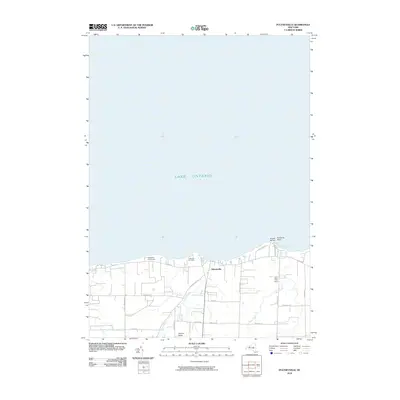
2010 Map of Pultneyville
USGS Topo · Published 2010About this map
The lakeside community of Pultneyville occupies the northern edge of Wayne County in this 2010 topographic survey, where the terrestrial landscape meets the southern reaches of Lake Ontario. The area is defined by its deep agricultural roots, evidenced by several prominent operations including Orbakers Fruit Farm, Lagoner Farms, and Noto Fruit Farm. These large holdings sit alongside a network of local roads such as Stoney Lonesome Rd and Tuckahoe Rd that cross the drainage basins of Salmon Creek and Mink Creek. Near the shoreline, Fairbanks Point and Holland Cove provide protected harbor for maritime activity at Hughes Marina. Cultural landmarks like the Lakeview Cemetery anchor the settled portions of the township, while the grid of roads stretching south toward Eaton Rd reflects the enduring rural character of this Finger Lakes region shoreline.
Find a feature on this map
29 named features on this map. Tap any name to fly to it.
Don’t see what you’re looking for? This feature index may not catch every label — zoom into the map to look around manually.
Map Details
Editions of this 2010 Pultneyville Map
This is the sole edition of this map. No revisions or reprints were ever made.
Other maps of this area

1899 · Palmyra
USGS Topo · 1:62,500

1900 · Macedon
USGS Topo · 1:62,500

1902 · Pultneyville
USGS Topo · 1:62,500

1902 · Palmyra
USGS Topo · 1:62,500

1942 · Ontario
USGS Topo · 1:31,680

1942 · Pultneyville
USGS Topo · 1:31,680

1943 · Williamson
USGS Topo · 1:31,680

1943 · Sodus
USGS Topo · 1:31,680
1952 · Salmon Creek
USGS Topo · 1:24,000
1952 · Pultneyville
USGS Topo · 1:24,000