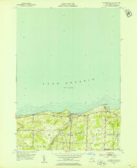
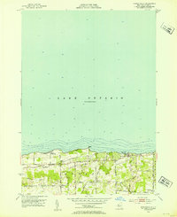
1952 Map of Pultneyville
USGS Topo · Published 1953About this map
Pultneyville sits at the center of this shoreline survey, serving as a focal point along the southern coast of Lake Ontario. The landscape is defined by the rural character of the Town of Williamson, where a network of family-named roads like Tuckahoe Road and Yeomans Road connects agricultural lands and small woodlots. Near the water, topographical details highlight natural features such as Holland Cove and Fairbanks Point, while the inland drainage is managed by Mink Creek and Salmon Creek. Genealogists may find interest in the Lakeview Cem, situated just west of the main settlement. The map reflects a mid-century period before significant modern coastal development, preserving the layout of historic orchards and farms that long characterized this portion of Wayne County. Surveying was overseen by the State of New York Department of Public Works and the USGS, capturing the area's transition into the post-war era.
Find a feature on this map
21 named features on this map. Tap any name to fly to it.
Don’t see what you’re looking for? This feature index may not catch every label — zoom into the map to look around manually.
Map Details
Editions of this 1952 Pultneyville Map
Other maps of this area

1899 · Palmyra
USGS Topo · 1:62,500

1900 · Macedon
USGS Topo · 1:62,500

1902 · Pultneyville
USGS Topo · 1:62,500

1902 · Palmyra
USGS Topo · 1:62,500

1942 · Ontario
USGS Topo · 1:31,680

1942 · Pultneyville
USGS Topo · 1:31,680

1943 · Williamson
USGS Topo · 1:31,680

1943 · Sodus
USGS Topo · 1:31,680
1952 · Salmon Creek
USGS Topo · 1:24,000
1952 · Furnaceville
USGS Topo · 1:24,000