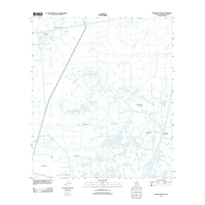
2012 Map of Pumpkin Islands
USGS Topo · Published 2012About this map
Pumpkin Islands and the surrounding marshlands of Vermilion Parish are defined by an intricate network of coastal hydrology and industrial infrastructure. This 2012 survey illustrates the significant role of the energy sector in this landscape, dominated by the East White Lake Oil and Gas Field and the Northern Freshwater Bayou Oil and Gas Field. These industrial sites are linked by man-made waterways like the Schooner Bayou Canal and the Freshwater Bayou Canal, which cut through the natural drainage of Hackberry Bayou and Little Bayou Chene. Prominent landforms such as Robert Ridge, Long Island, and Lost Island rise above the wetlands, marking the habitable or accessible high ground used for navigation and resource extraction. At the southern edge, Boat Point and Marina RD indicate the critical interfaces between the terrestrial environment and the Gulf-oriented water systems.
Find a feature on this map
15 named features on this map. Tap any name to fly to it.
Don’t see what you’re looking for? This feature index may not catch every label — zoom into the map to look around manually.
Map Details
Editions of this 2012 Pumpkin Islands Map
This is the sole edition of this map. No revisions or reprints were ever made.
Other maps of this area

1932 · Abbeville SW
USGS Topo · 1:31,680

1932 · Pecan Island SE
USGS Topo · 1:31,680

1932 · Pecan Island SW
USGS Topo · 1:31,680

1945 · Pecan Island NW
USGS Topo · 1:31,680

1945 · Pecan Island NE
USGS Topo · 1:31,680

1946 · Redfish Point SW
USGS Topo · 1:31,680

1946 · Schooner Bayou SE
USGS Topo · 1:31,680

1946 · Redfish Point NW
USGS Topo · 1:31,680

1946 · Schooner Bayou SW
USGS Topo · 1:31,680

1951 · Pecan Island
USGS Topo · 1:62,500