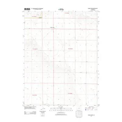
2013 Map of Punkin Center
USGS Topo · Published 2013About this map
Punkin Center serves as the central hub for this high-plains landscape, situated at the intersection of Co-94 and Co-71. The terrain is defined by a series of intermittent watercourses, including Mustang Cr in the north and the meandering path of Horse Cr to the south. These drainage patterns illustrate the region's delicate hydraulic geography, where life and settlement were historically bound to the seasonal flow of the creeks. The northern boundary of the map follows the line between Elbert Co and Lincoln Co, highlighting the administrative division of this rural ranching country. A grid of county roads, such as CO Road Y and CO Road 24, provides structure to the vast open sections, documenting the modern transport network that connects this remote corner of Colorado.
Find a feature on this map
18 named features on this map. Tap any name to fly to it.
Don’t see what you’re looking for? This feature index may not catch every label — zoom into the map to look around manually.
Map Details
Editions of this 2013 Punkin Center Map
This is the sole edition of this map. No revisions or reprints were ever made.
Other maps of this area

1889 · Sanborn
USGS Topo · 1:125,000

1891 · Sanborn
USGS Topo · 1:125,000

1893 · Sanborn
USGS Topo · 1:125,000

1954 · Lamar
USGS Topo · 1:250,000

1958 · Lamar
USGS Topo · 1:250,000

1975 · Stanley Gulch
USGS Topo · 1:24,000
1975 · Kutch
USGS Topo · 1:24,000

1977 · Punkin Center
USGS Topo · 1:24,000
1978 · Beckman Lake
USGS Topo · 1:24,000
1978 · Peace Valley
USGS Topo · 1:24,000