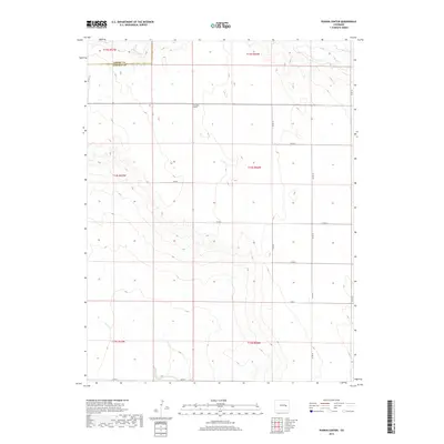
2019 Map of Punkin Center
USGS Topo · Published 2019About this map
Pumpkin Center sits at a remote crossroads in the eastern Colorado plains, marking a significant point of human presence in a landscape defined by intermittent drainage and vast agricultural sections. Situated near the border of Elbert Co and Lincoln Co, this area is characterized by the subtle topographies of the High Plains, where water courses like Mustang Cr and S Rush Cr dictate the historical and modern layout of the land. Further south, Horse Cr traverses the terrain, highlighting the sparse but vital water network of the region. The map reveals a strictly organized grid of county roads, such as Co RD 22 and Co RD X, which serve the isolated homesteads and ranching operations that have long sustained this corner of the state.
Find a feature on this map
21 named features on this map. Tap any name to fly to it.
Don’t see what you’re looking for? This feature index may not catch every label — zoom into the map to look around manually.
Map Details
Editions of this 2019 Punkin Center Map
This is the sole edition of this map. No revisions or reprints were ever made.
Other maps of this area

1889 · Sanborn
USGS Topo · 1:125,000

1891 · Sanborn
USGS Topo · 1:125,000

1893 · Sanborn
USGS Topo · 1:125,000

1954 · Lamar
USGS Topo · 1:250,000

1958 · Lamar
USGS Topo · 1:250,000

1975 · Stanley Gulch
USGS Topo · 1:24,000
1975 · Kutch
USGS Topo · 1:24,000

1977 · Punkin Center
USGS Topo · 1:24,000
1978 · Beckman Lake
USGS Topo · 1:24,000
1978 · Peace Valley
USGS Topo · 1:24,000