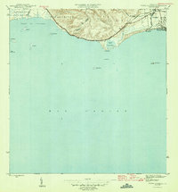
1946 Map of Punta Cuchara
USGS Topo · Published 1946About this map
American Railroad of Porto Rico tracks trace the Caribbean shoreline here, connecting the coastal plains of Barrio Playa to the industrial and agricultural hubs of the mid-1940s. The landscape is defined by the transition from the steep, contoured hills of Encarnación to the low-lying wetlands and salt flats near Laguna de las Salinas. Coastal activity centers around Playa de Ponce, where the settlement meets the Mar Caribe near the U S Mil Res and the historic Hacienda Matilde. This 1943 survey captures a maritime-oriented economy just before the rapid industrialization of the postwar years, evidenced by the numerous offshore islands like Cayo Ratones and Cayo Cardona, the latter of which features a prominent Faro. The boundary between Municipio de Peñuelas and Municipio de Ponce divides the terrain where Rio Tallaboa meets the Bahía de Tallaboa.
Find a feature on this map
27 named features on this map. Tap any name to fly to it.
Don’t see what you’re looking for? This feature index may not catch every label — zoom into the map to look around manually.
Map Details
Editions of this 1946 Punta Cuchara Map
3 editions found
Other maps of this area

1945 · Playa De Ponce
USGS Topo · 1:30,000

1945 · Ponce
USGS Topo · 1:30,000

1946 · Punta Cuchara
USGS Topo · 1:30,000

1946 · Yauco
USGS Topo · 1:30,000

1946 · Punta Verraco
USGS Topo · 1:30,000

1946 · Penuelas
USGS Topo · 1:30,000

1947 · Punta Gughara NE
USGS Topo · 1:10,000
1947 · Yauco SE
USGS Topo · 1:10,000

1947 · Ponce SO
USGS Topo · 1:10,000
1947 · Punta Verraco NE
USGS Topo · 1:10,000