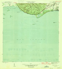
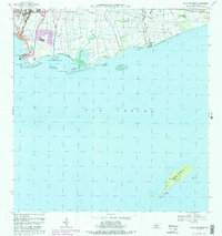
1946 Map of Punta Cuchara
USGS Topo · Published 1946About this map
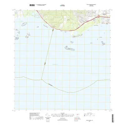
The Mar Caribe coastline near Ponce reveals a mid-century landscape of coastal agriculture and early industrial infrastructure. The American Railroad parallels the shore, connecting the settlement of Playa de Ponce to the interior, while Hacienda Matilde sits near the mouth of the Rio Matilde. This 1943 survey, published in 1946, details a terrain where tidal flats like Laguna de las Salinas meet the limestone rise of the Peñón de Ponce. Offshore, a string of small islands including Cayo Ratones and Cayo Cardona—the latter marked with a Faro—guard the approach to the Bahía de Tallaboa. The map also identifies a U S Mil Res near the coast, reflecting the strategic importance of the island's southern ports during the post-war era.
Find a feature on this map
25 named features on this map. Tap any name to fly to it.
Don’t see what you’re looking for? This feature index may not catch every label — zoom into the map to look around manually.
Map Details
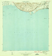
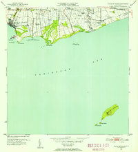
Editions of this 1946 Punta Cuchara Map
3 editions found
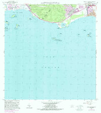
Historical Maps of Villa Laramia Through Time
23 maps found

1945 Playa De Ponce
Ponce Municipio, PR

1946 Punta Cuchara
Ponce Municipio, PR

1947 Adjuntas SE
Ponce Municipio, PR

1947 Jayuya SO
Ponce Municipio, PR

1947 Penuelas NE
Ponce Municipio, PR

1947 Penuelas SE
Ponce Municipio, PR

1947 Playa De Ponce NO
Ponce Municipio, PR

1947 Ponce NO
Ponce Municipio, PR

1947 Ponce SO
Ponce Municipio, PR

1947 Punta Gughara NE
Ponce Municipio, PR
1952 Playa De Ponce
Ponce Municipio, PR

1952 Punta Cuchara
Ponce Municipio, PR

1958 Playa De Ponce
Ponce Municipio, PR

1958 Punta Cucharas
Ponce Municipio, PR

1962 Playa De Ponce
Ponce Municipio, PR
1962 Punta Cucharas
Ponce Municipio, PR
1970 Playa De Ponce
Ponce Municipio, PR
2013 Playa De Ponce
Ponce Municipio, PR
2013 Punta Cucharas
Ponce Municipio, PR
2018 Playa De Ponce
Ponce Municipio, PR
2018 Punta Cucharas
Ponce Municipio, PR

2024 Playa De Ponce
Ponce Municipio, PR

2024 Punta Cucharas
Ponce Municipio, PR