
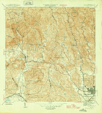
1947 Map of Punta Gughara NE
USGS Topo · Published 1947About this map
Hacienda Matilde and the surrounding agricultural lands define the coastal landscape west of Playa de Ponce in this mid-century topographic study. The map illustrates a transitional period where rural haciendas and small settlements like Los Pámpanos remained prominent near the growing urban port. The shoreline is characterized by significant coastal features, including the Laguna de las Salinas and the marshy deltas where the Río Matilde and Quebrada del Agua meet the Mar Caribe. Maritime safety is marked by the Faro on the coast and offshore markers like Cayo Cardona. The presence of the Mil Res area near the shoreline suggests the strategic importance of this coastline during the post-war era, while the detailed topography from Pta Cuchara to the inland hills reveals the complex drainage patterns essential for the local sugar economy.
Find a feature on this map
16 named features on this map. Tap any name to fly to it.
Don’t see what you’re looking for? This feature index may not catch every label — zoom into the map to look around manually.
Map Details
Editions of this 1947 Punta Gughara NE Map
This is the sole edition of this map. No revisions or reprints were ever made.
Other maps of this area

1945 · Playa De Ponce
USGS Topo · 1:30,000

1945 · Ponce
USGS Topo · 1:30,000

1946 · Punta Cuchara
USGS Topo · 1:30,000
1946 · Penuelas
USGS Topo · 1:30,000

1947 · Ponce SO
USGS Topo · 1:10,000
1947 · Penuelas SO
USGS Topo · 1:10,000
1947 · Punta Gughara NO
USGS Topo · 1:10,000

1947 · Penuelas SE
USGS Topo · 1:10,000

1947 · Playa De Ponce NO
USGS Topo · 1:10,000
1952 · Playa De Ponce
USGS Topo · 1:30,000