1947 Map of Punta Gughara NO
USGS Topo · Published 1947About this map
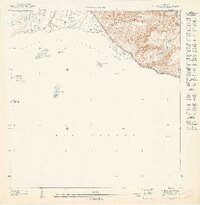
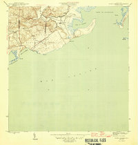
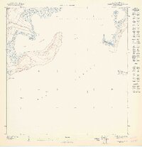
Bahia de Tallaboa and the southern coastline of Puerto Rico are the focal points of this 1943 topographical survey. The map details the transition from the Caribbean waters of the Mar Caribe to the steep elevation change at Peñon de Ponce, where the municipal boundary between Municipio Peñuelas and Municipio Ponce is established. The coastal landscape is defined by several small islands, including Cayo Río, Cayo Parguera, and Cayo María Langa, which sit offshore from the mouth of the Rio Tallaboa.
Find a feature on this map
12 named features on this map. Tap any name to fly to it.
Don’t see what you’re looking for? This feature index may not catch every label — zoom into the map to look around manually.
Map Details
Editions of this 1947 Punta Gughara NO Map
This is the sole edition of this map. No revisions or reprints were ever made.
Other maps of this area

1946 · Punta Cuchara
USGS Topo · 1:30,000

1946 · Yauco
USGS Topo · 1:30,000
1946 · Punta Verraco
USGS Topo · 1:30,000
1946 · Penuelas
USGS Topo · 1:30,000

1947 · Punta Gughara NE
USGS Topo · 1:10,000
1947 · Yauco SE
USGS Topo · 1:10,000
1947 · Punta Verraco NE
USGS Topo · 1:10,000
1947 · Penuelas SO
USGS Topo · 1:10,000

1947 · Penuelas SE
USGS Topo · 1:10,000

1952 · Punta Cuchara
USGS Topo · 1:30,000