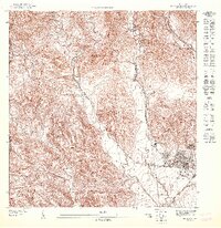
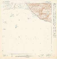
1947 Map of Penuelas SE
USGS Topo · Published 1947About this map
The western outskirts of Ponce and the neighboring Peñuelas boundary define this 1940s landscape. This survey captures a moment of infrastructure development, where the American Railroad and the coastal route through Los Pámpanos connect the agricultural interior to the urban center. The terrain is marked by sharp relief, with the Escuela Industrial de Niñas situated in the northern hills above the winding courses of the Río Portugués and Canas.
Find a feature on this map
12 named features on this map. Tap any name to fly to it.
Don’t see what you’re looking for? This feature index may not catch every label — zoom into the map to look around manually.
Map Details
Editions of this 1947 Penuelas SE Map
This is the sole edition of this map. No revisions or reprints were ever made.
Other maps of this area

1945 · Playa De Ponce
USGS Topo · 1:30,000

1945 · Ponce
USGS Topo · 1:30,000

1946 · Punta Cuchara
USGS Topo · 1:30,000

1946 · Penuelas
USGS Topo · 1:30,000

1947 · Punta Gughara NE
USGS Topo · 1:10,000
1947 · Penuelas NE
USGS Topo · 1:10,000

1947 · Ponce SO
USGS Topo · 1:10,000
1947 · Penuelas NO
USGS Topo · 1:10,000
1947 · Penuelas SO
USGS Topo · 1:10,000
1947 · Punta Gughara NO
USGS Topo · 1:10,000
Featured Places
- Sector Los Garcías, Ponce
- Sector La Vaquería, Ponce
- Ponce
- Canas Housing, Ponce
- Estancias del Madrigal, Ponce