
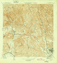
1947 Map of Ponce SO
USGS Topo · Published 1947About this map
The city of Ponce serves as the focal point of this 1940s-era topographic study, showing a detailed urban grid centered on the Ponce Cathedral and Plaza de Getau. The urban footprint is defined by the American Railroad and the winding course of the Rio Portugues, which separates the city center from developing neighborhoods like Alhambra. The surrounding landscape is dominated by a transition from the southern coastal plains to the foothills, where numerous agricultural estates such as Hacienda Barrancas and Hacienda Mallorquina characterize the land use of the period.
Find a feature on this map
35 named features on this map. Tap any name to fly to it.
Don’t see what you’re looking for? This feature index may not catch every label — zoom into the map to look around manually.
Map Details
Editions of this 1947 Ponce SO Map
This is the sole edition of this map. No revisions or reprints were ever made.
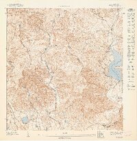
Other maps of this area

1945 · Playa De Ponce
USGS Topo · 1:30,000

1945 · Ponce
USGS Topo · 1:30,000

1946 · Punta Cuchara
USGS Topo · 1:30,000
1946 · Penuelas
USGS Topo · 1:30,000
1947 · Ponce NE
USGS Topo · 1:10,000
1947 · Playa De Ponce NE
USGS Topo · 1:10,000

1947 · Punta Gughara NE
USGS Topo · 1:10,000

1947 · Penuelas NE
USGS Topo · 1:10,000
1947 · Ponce SE
USGS Topo · 1:10,000

1947 · Penuelas SE
USGS Topo · 1:10,000