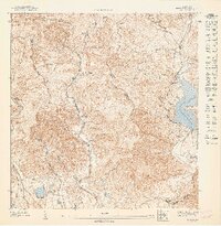
1947 Map of Ponce NE
USGS Topo · Published 1947About this map
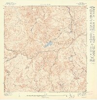
Hacienda Margarita and Hacienda Las Mamas anchor the agricultural landscape of this northern Juana Díaz region during the mid-1940s. The topography is dominated by the steep drainage of the Rio Guayo and Rio Guayabal, which feed into the prominent Lago Guayabal. This survey shows the transition of the local economy through clustered settlements like Poblado Collores and Poblado Real Arriba, where residential patterns follow the winding mountain roads and river valleys.
Find a feature on this map
26 named features on this map. Tap any name to fly to it.
Don’t see what you’re looking for? This feature index may not catch every label — zoom into the map to look around manually.
Map Details
Editions of this 1947 Ponce NE Map
This is the sole edition of this map. No revisions or reprints were ever made.
Other maps of this area

1945 · Ponce
USGS Topo · 1:30,000

1945 · Rio Descalabrado
USGS Topo · 1:30,000

1946 · Jayuya
USGS Topo · 1:30,000

1946 · Orocovis
USGS Topo · 1:30,000
1947 · Orocovis SO
USGS Topo · 1:10,000

1947 · Ponce SO
USGS Topo · 1:10,000
1947 · Ponce SE
USGS Topo · 1:10,000
1947 · Rio Descalabrado SO
USGS Topo · 1:10,000
1947 · Jayuya SE
USGS Topo · 1:10,000
1947 · Rio Descalabrado NO
USGS Topo · 1:10,000