1947 Map of Rio Descalabrado NO
USGS Topo · Published 1947About this map
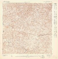
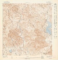
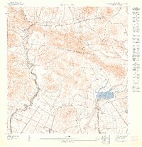
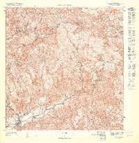
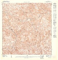
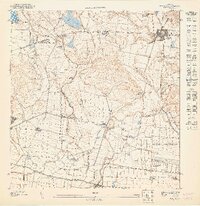
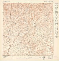
The interior mountains of Puerto Rico define this 1940s topographic study, centered on the boundary between Municipio de Villalba and Municipio de Juana Diaz. The drainage of the Rio Toa Vaca and Rio Jacaguas dominates the landscape, feeding into the southern reservoir of Lago Guayabal. This period of Puerto Rican history shows a rural mountain economy centered around small settlements like Poblado Guayabal and the rugged heights of Cerro de las Cuevas. The dense contouring illustrates the steep, fractured terrain typical of the Cordillera Central, where winding waterways like Quebrada Grande and Quebrada Gatos carve through the ridges. Notable local landmarks like La Mina and the course of the Rio Cañas provide specific reference points for researchers tracing the agrarian and hydraulic development of the region before modern industrialization.
Find a feature on this map
10 named features on this map. Tap any name to fly to it.
Don’t see what you’re looking for? This feature index may not catch every label — zoom into the map to look around manually.
Map Details
Editions of this 1947 Rio Descalabrado NO Map
This is the sole edition of this map. No revisions or reprints were ever made.
Other maps of this area

1945 · Ponce
USGS Topo · 1:30,000

1945 · Rio Descalabrado
USGS Topo · 1:30,000

1946 · Jayuya
USGS Topo · 1:30,000

1946 · Orocovis
USGS Topo · 1:30,000
1947 · Ponce NE
USGS Topo · 1:10,000
1947 · Rio Descalabrado SE
USGS Topo · 1:10,000
1947 · Orocovis SO
USGS Topo · 1:10,000
1947 · Orocovis SE
USGS Topo · 1:10,000
1947 · Ponce SE
USGS Topo · 1:10,000
1947 · Rio Descalabrado NE
USGS Topo · 1:10,000
Featured Places
- Sector Magas, Juana Díaz
- Caonillas Arriba, Villalba
- Barrio Pueblo, Villalba
- Cerro Gordo, Villalba
- Emajagual, Juana Díaz