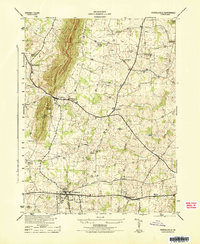
1944 Map of Purcellville
USGS Topo · Published 1944About this map
The Washington and Old Dominion railroad serves as the primary artery for Loudoun County commerce in the mid-1940s, connecting the hubs of Purcellville and Hamilton. This survey by the Soil Conservation Service emphasizes the area's rural religious and social centers, notably the numerous country churches like Salem Church, Ketoctin Church, and Arnold Grove Church that anchor the surrounding farming communities. Small settlements such as Hillsboro, Wheatland, and Mechanicsville are depicted with their building-level footprints, revealing the dispersed residential patterns of Northern Virginia before postwar suburbanization. The landscape is defined by the drainage systems of the North Fork Catoctin Creek and South Fork Catoctin Creek, which carve through the terrain near the ridge at Sawmill.
Find a feature on this map
22 named features on this map. Tap any name to fly to it.
Don’t see what you’re looking for? This feature index may not catch every label — zoom into the map to look around manually.
Map Details
Editions of this 1944 Purcellville Map
This is the sole edition of this map. No revisions or reprints were ever made.
Other maps of this area

1884 · Harpers Ferry
USGS Topo · 1:125,000

1891 · Harpers Ferry
USGS Topo · 1:125,000

1893 · Harpers Ferry
USGS Topo · 1:125,000

1908 · Middletown
USGS Topo · 1:48,000

1910 · Antietam
USGS Topo · 1:62,500

1914 · Martinsburg
USGS Topo · 1:48,000

1916 · Martinsburg
USGS Topo · 1:62,500

1916 · Berryville
USGS Topo · 1:62,500

1939 · Berryville
USGS Topo · 1:48,000

1943 · Bluemont
USGS Topo · 1:24,000